


Choose the right photos, says Tracey Jones, and you can explore the world...
In many schools, geography is treated like the poor relation, yet it is a superb vehicle for developing an exciting, personalised curriculum. That’s not to say it isn’t a highly accessible and worthwhile subject in its own right, but many of the issues schools are currently striving to tackle - sustainability, community cohesion, global development, active citizenship - nestle within the remits of good geography.
As an example, the highly adaptable activities in this article can be used with KS1 and KS2 children to support any place, issue or topic study in geography. They implement a wide range of key skills and can be linked into English, maths, ICT and social education. The lessons have been tried and tested with pupils across a wide range of ability levels from P Scale 7 to level 5, and are also achievable for the vast majority of SEN children.
Whilst I’d like to take the credit for creating all of the following ideas, I must say that they represent a collection of activities and good practice that I have seen, used and refined during my time as a geography teacher, co-ordinator and trainer.
 Picking a photo
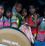
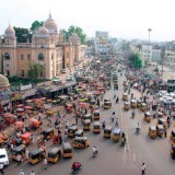
Choose images that include people – this is particularly useful for place study (e.g. India) and environmental issues (e.g. water use).
The activity
Children work in a small group to discuss what is happening in the photo. What clues can they spot in the image? Next they work together to recreate the image with each pupil adopting the position of a character in the photograph. One child could act as the director to move the others into place, checking the scene against the photo. Once in position, it’s time for ‘Action!’. Children bring the photo to life, adding speech and sounds where appropriate. Finally, freeze the scene in a new tableau. As a class, discuss what is really happening. What does this tell us about this place/issue and our interpretations?
Differentiation
Add thought-tapping for older children. Tap the frozen characters on the shoulder and asks them questions. What? Where? How?
 Picking a photo
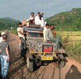
Find photos that show people – this is particularly useful for place study (e.g. Tocuaro) and environmental issues (e.g. deforestation).
The activity
Discuss what is happening in the photographs and then ask the children to consider what the people might be thinking or saying. Add speech and thought bubbles to the photograph using an overlay/polypocket, or onto a photocopy. Alternatively you could add speech and thought bubbles to a digital image created by the children (adding them to the new freeze frame tableau for the above activity, ‘Action!’, works really well too).
Differentiation
For lower achieving or younger pupils, consider the use of photos showing only one or two people. Higher achieving or older children might consider more complex images. Challenge them to consider the interaction between people or the thoughts people are having about each other.
 Picking a photo
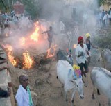
The images for this activity need to be more carefully selected. Try to find photos that display thoughtprovoking or contrasting scenes.
The activity
Cover up half of the photograph and photocopy it. Then get the children to ‘think outside the box’ bydrawing what could be missing. (This activity is especially good for drawing out and challenging cultural differences.) An adaptation of this activity is to use the whole image and ask the children to expand it to consider what would be to the left, right, above or below the scene. Imagine considering what is beneath a picture showing a row of houses (drains, sewers, cables) or above a rainforest (canopy, emergent zone, sky – what’s the weather like?). Finally, get the children to record who is in the photo. Where is it located? What is happening? why?
Differentiation
For less able or younger children consider hiding a smaller section of the scene from view. You can do this by covering part of the image up and then photocopying it.
 Picking a photo
Photos that contain a mixture of clues about where they were taken – along with the odd red herring – work best. Images that include a multicultural mix are especially good.
The activity
Children label the geographical features shown in the photograph and any clues they can spot that might give away its location (e.g. colour of skin, writing on signs, weather, etc.) They should ask themselves geographical questions that will help them to identify where the picture has been taken, and to rule out where it is not. Encourage children to spot similarities and differences between the photo and their own locality and other places/countries they might know.
Differentiation
Higher achievers should justify their opinions and make an overall decision about the location of the photo, finding it on an atlas. Use photos of the local setting with lower achieving or young children.
 Picking a photo
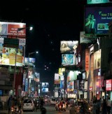
Find photographs of distant/contrasting locations. Try to avoid stereotypical images.
The activity
Children simply ask as many questions as they can about the photo, its setting, climate, features, people etc. Once the simple and obvious questions have been exhausted, children have to become more creative, which draws out deeper thinking. An alternative to this activity is for children to label what they know, think they know and would like to know about a place e.g. a photo of Serrekunda in The Gambia) or issue (e.g. a rainforest being cleared) or theme (e.g. an aerial photo of a river basin). This approach can also be used as the starting point to a unit as it gives the teacher and children clear ideas to investigate.
Differentiation
You could suggest that younger children ask questions about particular categories, e.g. weather, clothes, jobs, buildings, etc.
Pictures can be from a photo pack, an image that you or your children have taken, or an image found in a book or online. The important thing, however, is to consider how you will use the photo. What does the photograph tell you? How can it best be used? Having a clear purpose or learning objective in mind will help you select the right photograph and activity. Where possible, children should always be able to see the original colour photograph while they are working.
These photographs have been used with the kind permission of ActionAid, the international development charity, the Indian NGO ACCORD and the community organisation Adivasi Munnetra Sangam. Chembakolli, illustrated here, is a remote village in the forest area of south India, which is studied by primary school children all over the UK. ActionAid, which produces award winning schools resources, is one of the few organisations that work directly with the Adivasi people. The village of Chembakolli was established in 1988 by the Adivasi tribal people of southern India, after a long struggle to regain their rights to land.
Visit ActionAid’s schools page at http://www.actionaid.org.uk/schools
 Discover new ideas and share your own with a network of geography teachers, suggests Dr Paula Owens…
Geography Champions is part of the Action Plan for Geography, an initiative funded by the previous government and implemented by both the Geographical Association (GA) and the Royal Geographical Society with the Institute of British Geographers (RGS IBG). This GA led, primary focused project nurtures and supports nationwide networks of primary teachers, using local leadership provided by more than 50 appointed Geography Champions such as Tracey Jones.
Our Geography Champions offer a hub of support through a mix of local meetings and online networking. More than 1000 teachers alone participate through the Champions ‘Ning’ – a dedicated, collaborative and professional networking space. Do come and join us and share your queries, resources and best practice as we work together to develop lively, engaging and relevant geography within a broad and balanced primary curriculum.
• The Geography Association http://www.geography.org.uk
• Champions Ning http://geographychampions.ning.com
Dr Paula Owens is Curriculum Development Leader (primary) the Geographical Association
Tracey Jones works as a teacher at Whipton Barton School in Exeter. She is also a Primary Geography Champion, helping to support and train colleagues in Exeter and Devon. You can join Tracey and her Champion colleagues at http://geographychampions.ning.com


Power Maths – A Child-Centred, ‘Can-Do’ Mastery Teaching Programme for KS1 and KS2
Category: Maths

Fit To Dance Schools From Disney On Ice
Category: Other

‘S!ng Sensational’ And ‘A King Is Born’ – Two Fun New Musical Masterpieces That Children Will Love
Category: Music
Product review: Schofield & Sims Fractions, Decimals & Percentages
Category: Maths
If your marking doesn’t affect pupil progress - stop it!
Ace-Classroom-Support

Pie Corbett’s bike poems
Topic


